The Origin of the Appalachian Mountains
The Origin of the Appalachian Mountains
Earth is a very dynamic place. Not only does weather affect the surface, as well as tides and various other phenomena that we witness during the course of our lives, but it has changed even more dramatically over long time scales, far beyond the lives of any one person, or in many cases even the existence of our species. The continents move. Over the billions of years since Earth’s formation, continents have formed, moved around, merged, broken up, and subducted out of existence. By studying the magnetic alignment of the rocks as well as their age, composition, form, and even the fossils found in them, the ancient arrangement of the continents can be understood.
To gain an understanding of how mountains are formed, there are some basic concepts that must be understood. The crust of the Earth is broken up into plates which drift around on geologic timescales. The boundaries of these plates may be fixed or dynamic. Convergent plate boundaries are where some of the most dynamic interactions occur. Cold oceanic crust may sub-duct, or sink, below another plate, dragging the rest of the plate with it. Divergent plate boundaries are separated by spreading zones where hot magma rises from Earth’s interior, filling the emergence area with fresh crust. The continental crust is typically made of lower density rocks than the oceanic crust. If two plates collide with one another dynamically, several outcomes may occur, but usually the result is an orogeny, or mountain building episode.
If continental crust collides with continental crust, the continental crust on both sides will fracture, buckle, and fault, giving rise to mountain ranges like the Himalayas, where India is driving northwards into Asia. If oceanic crust collides with continental crust the denser oceanic crust typically sub-ducts or sinks below the less dense continental crust. As the oceanic crust sinks below the continental crust, it heats up and melts. This melted oceanic crust rises back to the surface from under the continental crust and creates mountains in the form of a volcanic back-arc on the continental crust. Oceanic crust on the leading edge of a plate may sub-duct under oceanic crust on the opposite side of the convergent plate boundary. Volcanic island arcs may form on the opposite side and as the plates converge, the subduction zone and volcanic islands may merge with the continental crust and form mountains in the collision and putting a halt to further subduction.
Other variations of the above mechanisms may happen as well, but the above covers the basics. Many orogenies have happened in many places around the world throughout Earth’s history. I’m going to focus on one particular area, the modern-day East coast of North America and what we now know as the Appalachian Mountain range and its history. The times for specific events are often fuzzy and may still be debated in the literature so the following exploration is based on the data available in the Wolfram Language and provided by Christopher Scotese.
Utility Functions
Utility Functions
In[]:=
WorldMap[period_,key_,annotations_]:=Module[{keys},keys=Keys[EntityValue[period,"ContinentalPlates"]];GeoGraphics[{EdgeForm[],GeoStyling["OutlineMap",LightOrange],EntityValue[period,"ContinentalPlates"][[key]],GrayLevel[.4],annotations},GeoBackgroundDarker[LightBlue,.2],GeoProjection"Mollweide",GeoRangeAll,GeoGridLinesAutomatic,ImageSize650,PlotLabelStyle[period["Name"]<>" "<>ToString[QuantityMagnitude[Quantity[FromDigits[StringReplace[DateString[keys[[key]],{"Year"}],"-"""]],"Years"],"Megayears"]]<>" mya",36]]]
In[]:=
ZoomMap[period_,key_,annotations_,center_,range_]:=Module[{keys},keys=Keys[EntityValue[period,"ContinentalPlates"]];GeoGraphics[{EdgeForm[],GeoStyling["OutlineMap",LightOrange],EntityValue[period,"ContinentalPlates"][keys[[key]]],annotations},GeoBackgroundDarker[LightBlue,.2],GeoGridLinesAutomatic,GeoCentercenter,GeoRangerange,ImageSize600]]
In[]:=
text[label_,size_,color_,angle_,latlon_]:=Text[Rotate[Style[label,size,color],angleDegree],GeoPosition[latlon]]
Taconic Orogeny
Taconic Orogeny
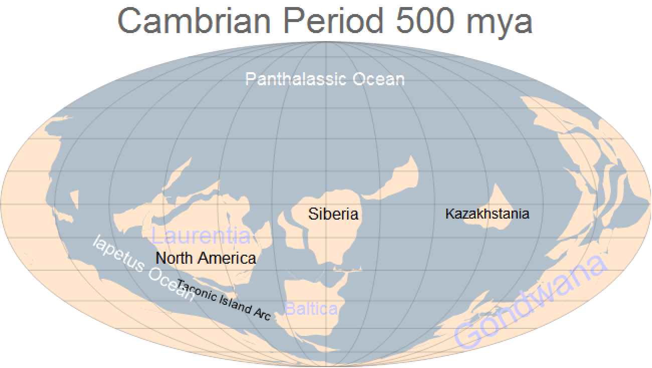
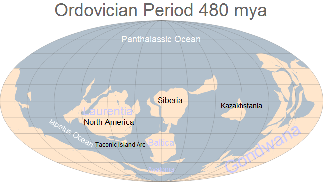
During the Cambrian Period, about 500 million years ago, most of the modern continents today were in very different configurations and, in many cases, had not even assembled themselves completely. Proto-North America, known as Laurentia was near the equator, perhaps a little south of it, and rotated compared today with the modern East coast facing south. The large southern continent of Gondwana stretched across the south pole. The ocean between Laurentia and Gondwana, known as the Iapetus Ocean, began to close. A subduction zone had formed off of the modern East coast and as the ocean floor subducted, it melted and formed magma that rose to form the Taconic island arc on the opposite side of the subduction zone from Laurentia.
In[]:=
WorldMap,1,text"Gondwana",36,,30,{-45,140},text"Laurentia",24,,0,{-15,-70},text"North America",16,,0,{-25,-70},text"Baltica",18,,0,{-50,-10},text"Siberia",16,,0,{-5,5},text"Kazakhstania",14,,0,{-5,90},text"Taconic Island Arc",12,,-20,{-45,-70},text"Panthalassic Ocean",18,,0,{60,0},text"Iapetus Ocean",18,,-30,{-30,-110}


Out[]=
In[]:=
WorldMap,3,text"Gondwana",36,,30,{-45,140},text"Laurentia",24,,0,{-10,-60},text"North America",16,,0,{-20,-60},text"Baltica",18,,0,{-40,0},text"Avalonia",14,,0,{-70,0},text"Siberia",16,,0,{0,10},text"Kazakhstania",14,,0,{-5,90},text"Taconic Island Arc",12,,0,{-42,-55},text"Panthalassic Ocean",18,,0,{60,0},text"Iapetus Ocean",16,,-30,{-30,-110}
Out[]=
In[]:=
ZoomMap,3,text"Laurentia",24,,0,{-10,-60},text"North America",16,,0,{-20,-60},text"Taconic Island Arc",12,,0,{-42,-55},text"Avalonia",18,,0,{-71,-30},text"Iapetus Ocean",18,,0,{-50,-60},GeoPosition[{-25,-60}],Quantity[3400,"Miles"]
Out[]=
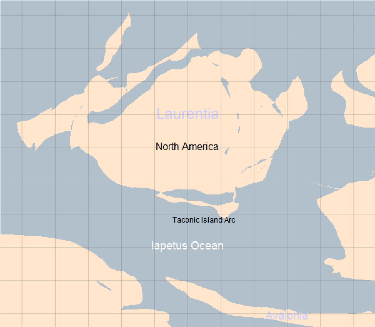
Between the Ordovician and Silurian Periods the Taconic Islands had sutured themselves onto the modern East coast, onto Laurentia.The folding and faulting of the rocks as this event occurred led to metamorphism of the local rocks and resulted in the Taconic Orogeny. Mountains appeared on the modern East coast near present day New England and the subduction stopped. These mountains ran from New England through modern day western Connecticut and through southern New York and the Bronx and were the first phase of the building of what we would one day call the Appalachian mountains.
Interestingly, the northern part of the modern-day East coast was on the subducting plate during the Taconic orogeny, but this was not true further south. The southern Appalachian mountains show no evidence of island arcs being sutured onto the ancient coast line. Instead, it seems that the Iapetus ocean was subducting under Laurentia. This caused a volcanic arc to form on the Laurentian plate, the location of modern day Alabama, Georgia, and North Carolina. After the Taconic Orogeny ended, things became quiet again.
Acadian Orogeny
Acadian Orogeny
During the early Silurian, the last remnants of the Iapetus Ocean was closing between Laurentia and the Baltic and Avalonian terrains approaching from the southeast. The Rheic Ocean was opening behind them.
In[]:=
WorldMap,3,text"Gondwana",36,,30,{-45,140},text"Laurentia",18,,0,{0,-40},text"North America",16,,0,{-10,-45},text"Baltica",18,,0,{-20,5},text"Siberia",16,,0,{20,5},text"Kazakhstania",14,,0,{-5,70},text"Panthalassic Ocean",18,,0,{60,0},text"Iapetus Ocean",14,,20,{-35,-40},text"Rheic Ocean",18,,0,{-50,-10}
As time progressed through the Late SIlurian and into the Devonian Period, the Avalonian terrains were merging with Laurentia.
By the Middle Devonian the suturing of the Avalonian terrains had been completed and the Rheic Ocean was closing.
Alleghanian Orogeny
Alleghanian Orogeny
As the Devonian Period made way for the Carboniferous Period, about 360 million years ago, Gondwana was continuing to move northward and approaching Laurentia. By the late Carboniferous, about 300 million years ago, both Laurentia and Gondwana had merged along with most of Asia in the north. Together, the supercontinent of Pangea was formed. The collision of Laurentia and Gondwana resulted in a mountain building episode called the Alleghanian Orogeny, or Appalachian Orogeny.
Pangea Breakup
Pangea Breakup
The last major mountain building episode for the Appalachian Mountains was around 300 million years ago during the Carboniferous Period as Pangea formed. Eventually, around 175 million years ago during the Jurassic Period, Pangea began to break apart approximately along the old Laurentia to Gondwana line. The mountains left behind on the northern side became the Appalachian Mountains, while the portion on the southern side, in present-day northwest Africa, became the Anti-Atlas Mountains (the High Atlas Mountains would form much later). During this time, there was major rifting across Pangea, but there was no mountain building going on in the area around the Appalachians as we know them today, so erosion began to dominate and wear the once high mountains down.
Zooming into the rifting area of Pangea near the Laurasia-Gondwana boundary, we can see the proto-Atlantic Ocean beginning to open up. Some modern continents are labeled, but had not yet separated from their respective super-continents.
By the end of the Mesozoic Era and the Late Cretaceous Period, the continents had continued to drift and started to take on appearance more like what we see today.
Over the last 66 million years since the end of the Cretaceous Period, erosion and weathering has continued. There is some debate concerning how the Appalachians look as they do today. Some theories state that what we see today are the weathered remains of ancient hard rocks that have amazingly resisted being totally eroded away, remnants of once tall mountains weathered down into relative smaller rounded peaks over the last 300 million years. But, recent research seems to indicate that the Appalachians may have been weathered down to a nearly flat plain by the end of the Cretaceous Period. By this theory, a later period of activity has caused the area where the mountains once were to be uplifted again. This uplift is not caused by colliding tectonic plates, but by lower level mantle activity. It is beyond the scope of this document to resolve this controversy, but regardless the Appalachian Mountain region has seen a tremendous amount of activity over the last 500 million years.
CITE THIS NOTEBOOK
CITE THIS NOTEBOOK
Mountain building and orogenies using GeoGraphics
by Jeffrey Bryant
Wolfram Community, STAFF PICKS, 2020
https://community.wolfram.com/groups/-/m/t/1815547
by Jeffrey Bryant
Wolfram Community, STAFF PICKS, 2020
https://community.wolfram.com/groups/-/m/t/1815547