Basic Examples 
(4)
 

Retrieve a comprehensive dataset of all radiosonde launch sites worldwide from the SondeHub registry:
In[1]:=
sites=
SondeHubSites
[]
Out[1]=
id
station
station_name
position
alt
rs_types
notes
datetime
times
@timestamp
98753
98753
Davao Airport (Philippines)
{125.655,7.1278}
17
{11}
—
2023-07-06T06:19:07Z
{0:00:00,0:12:00}
2021-11-23T22:08:57.409Z
98646
98646
Mactan (Philippines)
{123.98,10.3222}
23
{41}
—
2023-07-06T06:19:07Z
{0:00:00,0:12:00}
2021-11-23T22:08:57.409Z
98618
98618
Puerto Princesa (Philippines)
{118.759,9.7403}
14
{11}
—
2023-07-06T06:19:07Z
{0:00:00,0:12:00}
2021-11-23T22:08:57.409Z
98558
98558
Guiuan (Philippines)
{126.73,11.03}
56
{11}
—
2023-07-06T06:19:07Z
—
2021-11-23T22:08:57.409Z
98444
98444
Legaspi (Philippines)
{123.728,13.1506}
16
{41}
—
2023-07-06T06:19:07Z
{0:12:00,0:00:00}
2021-11-23T22:08:57.409Z
98433
98433
Tanay (Philippines)
{121.369,14.5814}
614
{11}
—
2023-07-06T06:19:07Z
{0:12:00,0:00:00}
2021-11-23T22:08:57.409Z
98328
98328
Baguio (Philippines)
{120.601,16.4039}
1500
{11}
—
2023-07-06T06:19:07Z
{0:00:00,0:12:00}
2021-11-23T22:08:57.409Z
98233
98233
Tuguegarao (Philippines)
{121.753,17.6375}
61
{11}
—
2023-07-06T06:19:07Z
{0:12:00,3:00:00,4:00:00,2:00:00,6:00:00}
2021-11-23T22:08:57.409Z
98223
98223
Laoag (Philippines)
{120.534,18.1828}
4
{11,18}
—
2023-07-06T06:19:07Z
{0:00:00,0:12:00}
2021-11-23T22:08:57.409Z
97980
97980
Merauke / Mopah (Indonesia)
{140.383,-8.4667}
3
{35}
—
2023-07-06T06:19:07Z
{0:00:00}
2021-11-23T22:08:57.408Z
97900
97900
Saumlaki (Indonesia)
{131.3,-7.9833}
24
{35}
—
2023-07-06T06:19:07Z
{0:00:00}
2021-11-23T22:08:57.409Z
97724
97724
Ambon / Pattimura (Indonesia)
{128.083,-3.7}
12
{35}
—
2023-07-06T06:19:07Z
{0:00:00}
2021-11-23T22:08:57.409Z
97560
97560
Biak / Mokmer (Indonesia)
{136.117,-1.1833}
11
{35}
—
2023-07-06T06:19:07Z
{0:00:00}
2021-11-23T22:08:57.409Z
97502
97502
Sorong / Jefman (Indonesia)
{131.286,-0.8939}
3
{77}
—
2023-07-06T06:19:07Z
{0:00:00}
2021-11-23T22:08:57.409Z
97372
97372
Kupang / El Tari (Indonesia)
{123.667,-10.1667}
108
{35}
—
2023-07-06T06:19:07Z
{0:00:00}
2021-11-23T22:08:57.409Z
97180
97180
Ujung Pandang / Hasanuddin (Indonesia)
{119.55,-5.0667}
14
{35}
—
2023-07-06T06:19:07Z
{0:00:00}
2021-11-23T22:08:57.408Z
97072
97072
Palu / Mutiara (Indonesia)
{119.733,-0.6833}
6
{35}
—
2023-07-06T06:19:07Z
{0:00:00}
2021-11-23T22:08:57.408Z
97014
97014
Menado / Dr. Sam Ratulangi (Indonesia)
{124.917,1.5333}
80
{35}
—
2023-07-06T06:19:07Z
{0:00:00}
2021-11-23T22:08:57.408Z
96996
96996
Cocos Island Airport (Christmas Island)
{96.8344,-12.1892}
3
{42}
—
2023-07-06T06:19:07Z
{0:00:00}
2021-11-23T22:08:57.407Z
96935
96935
Surabaya / Juanda (Indonesia)
{112.782,-7.37283}
3
{35}
—
2023-07-06T06:19:07Z
{0:00:00,0:12:00}
—
rows 1–20 of 892
columns 1–10 of 20
Data not saved. Save now
Fetch real-time telemetry data for all active radiosondes and high-altitude balloons currently being tracked globally:
In[2]:=
sondes=
SondeHubSondes
[]
Out[2]=
id
Y1112649
software_name
radiosonde_auto_rx
35 total ›
id
Y1112247
software_name
radiosonde_auto_rx
35 total ›
id
Y1052191
software_name
rdzTTGOsonde
30 total ›
id
Y0943015
software_name
radiosonde_auto_rx
36 total ›
id
Y0942980
software_name
radiosonde_auto_rx
36 total ›
id
Y0532290
software_name
rdzTTGOsonde
27 total ›
id
Y0512846
software_name
radiosonde_auto_rx
33 total ›
id
Y0512663
software_name
radiosonde_auto_rx
35 total ›
id
Y0512126
software_name
radiosonde_auto_rx
33 total ›
id
Y0322975
software_name
OpenWebRX+
22 total ›
rows 1–10 of 658
Examine details of one randomly chosen sonde:
In[3]:=
RandomChoice[sondes]
Out[3]=
id
X1623184
software_name
radiosonde_auto_rx
software_version
1.8.2
uploader_callsign
VE3ICD-2
uploader_position
43.4528,-80.38317
uploader_antenna
1/4 wave with LNA/Filter at Antenna
time_received
2026-05-14T01:27:26.192187Z
datetime
2026-05-14T01:27:42.007000Z
manufacturer
Vaisala
type
RS41
serial
X1623184
subtype
RS41-SG
frame
9054
lat
49.1477
lon
-82.3851
alt
32209.5
temp
-36.0
humidity
0.6
vel_v
-18.7144
vel_h
10.4729
rows 1–20 of 35
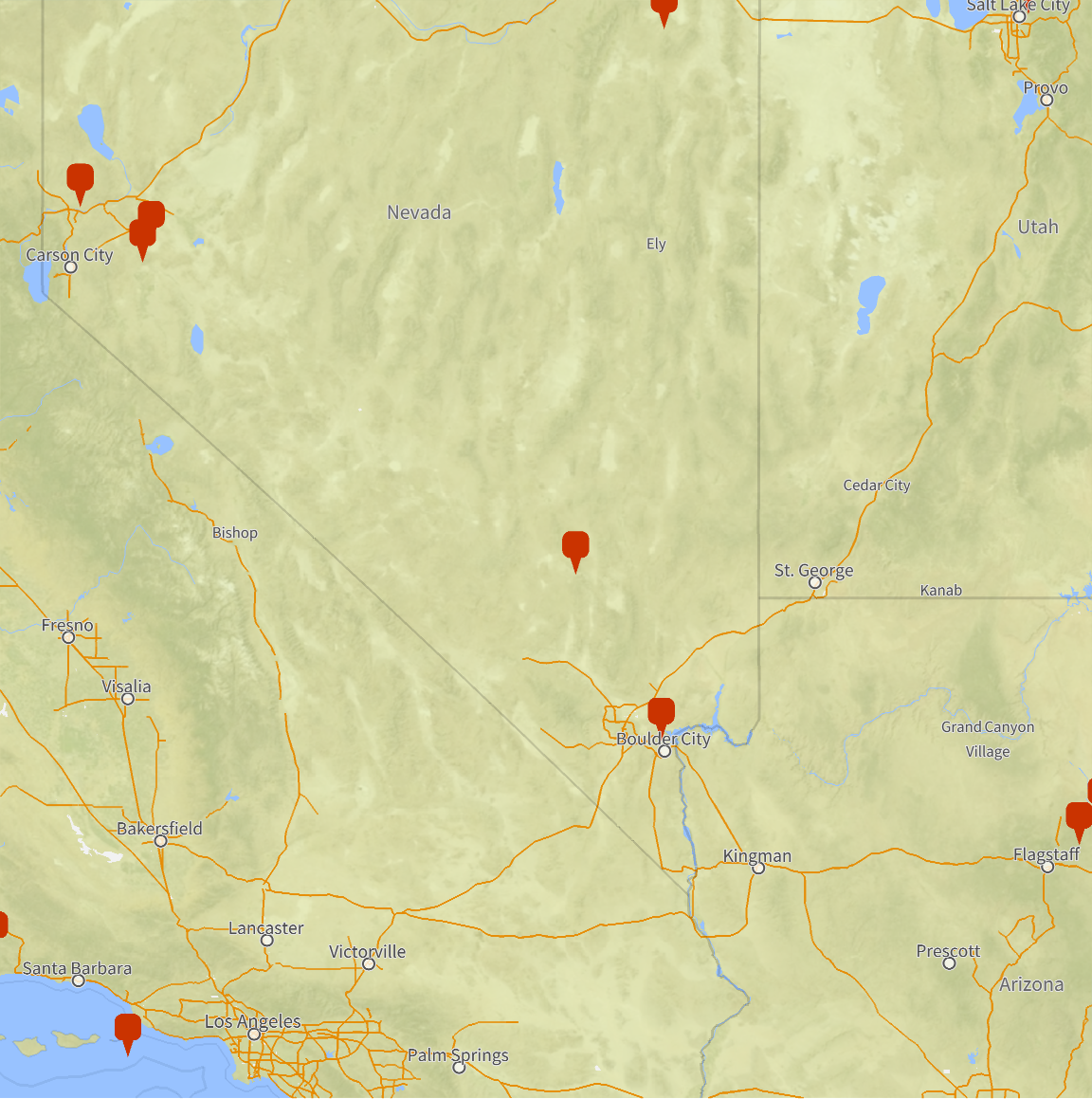
Visualize active radiosonde locations within a 250-mile radius of Area 51 (KXTA), demonstrating the use of custom
GeoGraphics
options for localized tracking:
In[4]:=
SondeHubGraphics
sondes,GeoCenter->
Area 51
AIRPORT
,GeoRange->Quantity[250,"Miles"],ImageSize->Large
Out[4]=

Scope 
(2)
 
