Coal is used to varying degrees worldwide to generate energy from power plants. Some countries and/or states use more than others. Recent decades have seen a decline in the popularity of the use of coal due to environmental concerns concerning the carbon dioxide released from coal burning in power plants. Regardless of the political views concerning the use of coal, the origins of coal and the location and age of the deposits are interesting from a geological point of view.
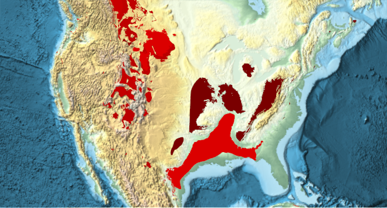
Living plants do an amazing job of removing carbon dioxide from the atmosphere and replacing it with oxygen. If plants die and are buried quickly and are prevented from completely decomposing, the carbon they keep locked up in their fibers can become coal. This conversion from plant matter to coal typically takes millions of years and exposure to high temperatures and pressure. Contrary to a common misconception, not all coal in the world, or even in the United States, was formed at the same time. The largest deposits in the United States were formed around 300 million years ago, but there are many smaller deposits near the Rocky Mountains, that are much younger.
Starting a little more than 300 million years ago, there were large areas west of the modern Appalachian Mountains, that were swampy. The plants that grew here died and were buried in oxygen poor water, allowing decomposition to be brought to a crawl forming large peat bogs. In addition, its possible that the organisms that break down lignin in plants may not have evolved yet, so plants containing lots of newly evolved lignin would not have been able to break these plant tissues down. But recent research questions this last theory so there is controversy involved. Regardless of these details, if you have large peat bogs that are exposed to high temperature and pressure, coal can form from the carbon these plants pulled from atmospheric carbon dioxide before they died. Reconstructions of the ancient atmosphere during the Carboniferous period indicate the amount of carbon dioxide during this period was far lower than before this, likely due to large areas of swamps pulling the carbon dioxide from the atmosphere.
Out[]=
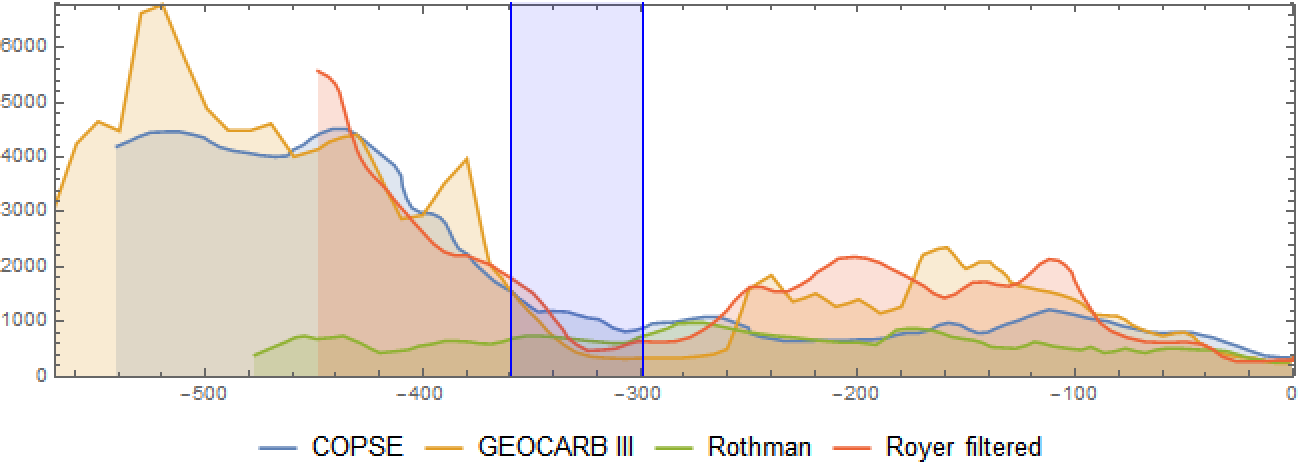
During the Carboniferous Period, ending around 300 million years ago, the supercontinent of Pangea formed. Africa collided with North America to the east and South America collided with North America from the south. These continental collisions provided the heat and pressure needed to convert these ancient peat bogs into coal. We can use data from the United States Geological Survey (USGS) to see where these coal beds are and also find out their age and type of coal. First, we need to know the datum used by the USGS data to make sure its compatible with GeoGraphics.
In[]:=
Import["https://pubs.usgs.gov/of/2008/1257/Americas_coal.zip","CoordinateSystemInformation"]
Out[]=
GEOGCS{GCS_WGS_1984,DATUM{WGS_1984,SPHEROID{WGS_1984,6.37814×,298.257}},PRIMEM{Greenwich,0.},UNIT{Degree,0.0174533}}
6
10
WGS84 doesn’t require any datum transformations so we should be good to use the data directly.
In[]:=
coaldata=Import["https://pubs.usgs.gov/of/2008/1257/Americas_coal.zip","Data"];
In[]:=
coaldata[[All,1]]
Out[]=
{LayerNameBoundaries,LayerNameAmericas_coalply,LayerNameCentral_American_coalpt}
The layer called “Boundaries” represents country/political boundaries so isn’t needed for my purposes here. The layer called “Americas_coalply” is where the coal data for North America is found. I can extract label information and geometry as follows.
In[]:=
coaldata[[2,All,1]]
Out[]=
{LayerName,Geometry,Labels,LabeledData}
In[]:=
labeleddata="LabeledData"/.coaldata[[2]];
In[]:=
coalgeom="Geometry"/.coaldata[[2]];
Coal Beds by Age
Coal Beds by Age
In[]:=
agelabels="age"/.labeleddata;
For each label value, I assign a rough time value for scaling and sorting purposes.
agerules={"Carboniferous"3.291*^8,"Cretaceous"1.055*^8,"Cretaceous-Tertiary"7.488*^7,"Devonian"3.876*^8,"Eocene"4.485*^7,"Jurassic"1.7255*^8,"Jurassic and Cretaceous"1.39*^8,"Jurassic to Upper Cretaceous"1.2755*^8,"Lower Cretaceous"1.23*^8,"Mesozoic"1.58*^8,"Middle Jurassic"1.684*^8,"Middle-Upper Jurassic"1.61*^8,"Miocene"1.418*^7,"Miocene-Oligocene"2.13*^7,"Mississippian"3.3865*^8,"Mississippian-Pennsylvanian"3.236*^8,"Oligocene"2.85*^7,"Oligocene-Paleocene"4.46*^7,"Paleozoic - no differentiation"3.96*^8,"Pennsylvanian"3.0855*^8,"Pennsylvanian and Permian"2.92*^8,"Permian"2.75*^8,"Pliocene"3.96*^6,"Pliocene-Oligocene"1.62*^7,"Quaternary-Tertiary"2.278*^7,"Tertiary"4.43*^7,"Triassic"2.253*^8,"Triassic-Jurassic"1.98925*^8,"Unknown"4*^8,"Upper Cretaceous"8.255*^7,"Upper Cretaceous and Lower Tertiary"6.34075*^7,"Upper Cretaceous-Tertiary"6.34076*^7,"Upper Jurassic"1.5335*^8,"Upper Jurassic-Lower Cretaceous"1.38*^8,"Upper Triassic-Lower Jurassic"2.007*^8,"Very Young"3.9*^6};
In[]:=
sortedagelabels=SortBy[Transpose[{DeleteDuplicates[agelabels],DeleteDuplicates[agelabels]/.agerules}],#[[2]]&][[All,1]];
We assign a unique color to each unique label. Darker reds are older than lighter reds.
In[]:=
MapIndexed[(coalagecolor[#1]=Blend[{Red,RGBColor[.1,0,0]},.02*First[#2]])&,sortedagelabels];
In[]:=
agegeompairs=Transpose[{coalgeom,agelabels}];
I represent each polygon with a unique color and provide a tooltip (you must re-evaluate the code to see these) to describe the age and type of coal found in that area.
In[]:=
agecoloredtooltip[poly_,label_]:={coalagecolor[label],Tooltip[poly,label]}
In[]:=
GeoGraphics{EdgeForm[],GeoStyling[Opacity[1]],agecoloredtooltip@@@agegeompairs},GeoBackground"ReliefMap",ImageSize650,GeoRange

Out[]=
Coal Beds by Type
Coal Beds by Type
Coal is often ranked based on its relative carbon content. Peat (~60% carbon) would have the lowest rank while more metamorphosed forms like anthracite, with the highest relative carbon content (~95%), has the highest rank. Anthracite is highly sought after due to its high carbon content combined with relatively low volatiles. Anthracite is often used in power plants and metallurgy due to its high energy density, but its more rare, accounting for only about 1% of global coal reserves. Roughly, the rank of coal increases from wood at the low end, followed by peat and then lignite, also known as brown coal. Higher than lignite comes various forms of bituminous coal and then anthracite at the highest end.
In[]:=
ranklabels="rank"/.labeleddata;
In[]:=
DeleteDuplicates[ranklabels]
Out[]=
{Lignite,Bituminous,Subbituminous,Anthracite to Semi-anthracite,Lignite to Subbituminous,Subbituminous to Bituminous,Subbituminous to High Volatile Bituminous,Low Volatile Bituminous to Anthracite,Not Reported,High Vol. Bituminous to Medium Vol. Bituminous,Low Vol. Bituminous to Medium Vol. Bituminous,High Volatile Bituminous,High Volatile Bituminous to Anthracite,Lignite to High Volatile Bituminous,Bituminous?,Subbituminous?,Subbituminous to High Vol. Bituminous,Bituminous to Meta-anthracite,Bituminous to Semi-anthracite,Bituminous to Anthracite,Subbituminous to Anthracite,Anthracite,Lignite to Peat,Lignite?,Low Vol. Bituminous to High Vol. Bituminous,Low Vol. Bituminous,Lignite to Bituminous,Medium Vol. to High Vol. Bituminous?,Medium Vol. to High Vol. Bituminous,High Vol. Bituminous to Low Vol. Bituminous,Lignite to Low Vol. Bituminous,Subbituminous to Lignite}
We assign a unique color to each label.
In[]:=
MapIndexed[(coaltypecolor[#1]=ColorData[106][First[#2]])&,DeleteDuplicates[ranklabels]];
The geometry is extracted as follows.
In[]:=
rankgeompairs=Transpose[{coalgeom,ranklabels}];
I represent each polygon with a unique color and provide a tooltip (you must re-evaluate the code to see these) to describe the age and type of coal found in that area.
In[]:=
typecoloredtooltip[poly_,label_]:={coaltypecolor[label],Tooltip[poly,label]}
In[]:=
GeoGraphics{EdgeForm[],GeoStyling[Opacity[1]],typecoloredtooltip@@@rankgeompairs},GeoBackground"ReliefMap",ImageSize650,GeoRange
Out[]=
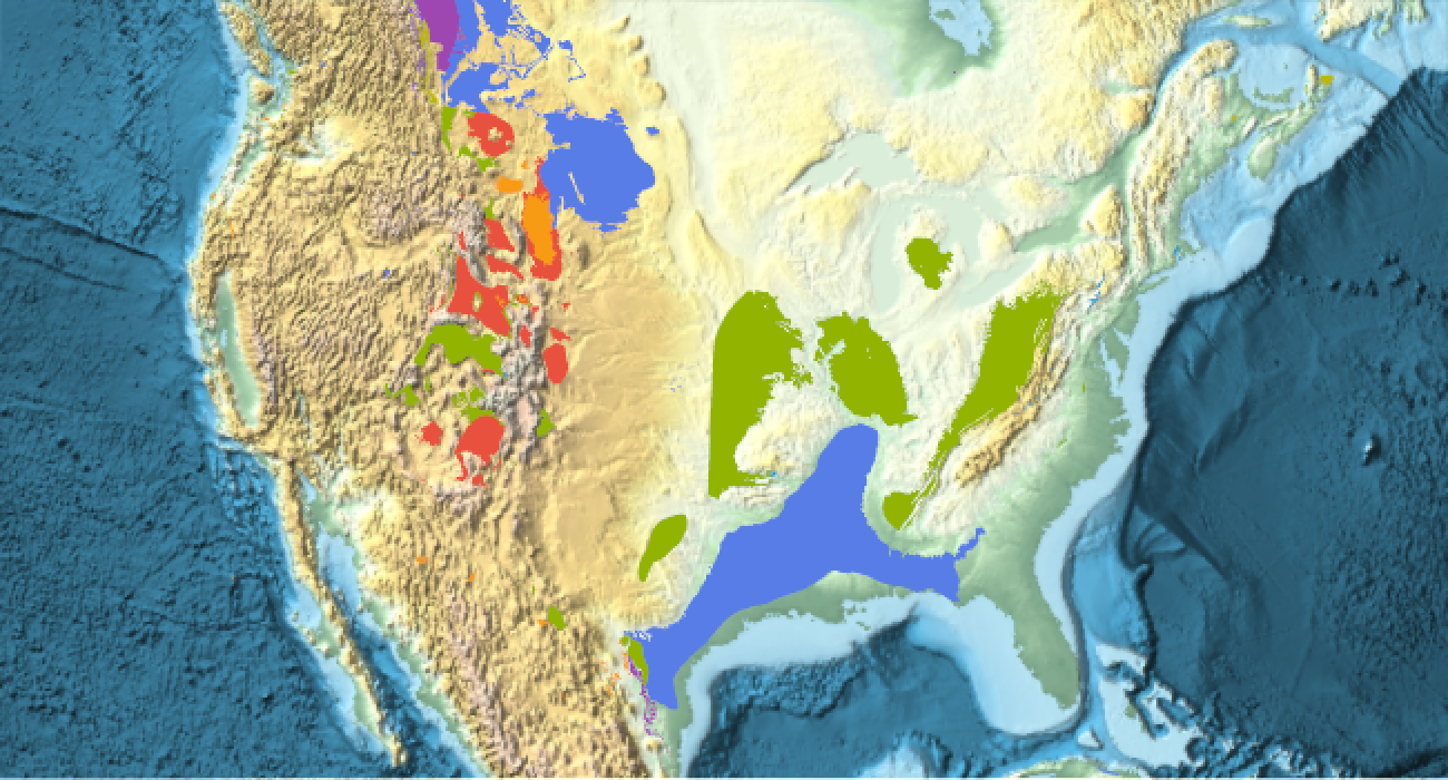
The coal found in much of the eastern United States and mid-west is bituminous coal, with small isolated pockets of anthracite in the northeast.
In[]:=
GeoGraphics{EdgeForm[],GeoStyling[Opacity[1]],typecoloredtooltip@@@rankgeompairs},ImageSize600,GeoBackground"ReliefMap",GeoRangeQuantity[500,"Miles"],GeoCenter
Out[]=
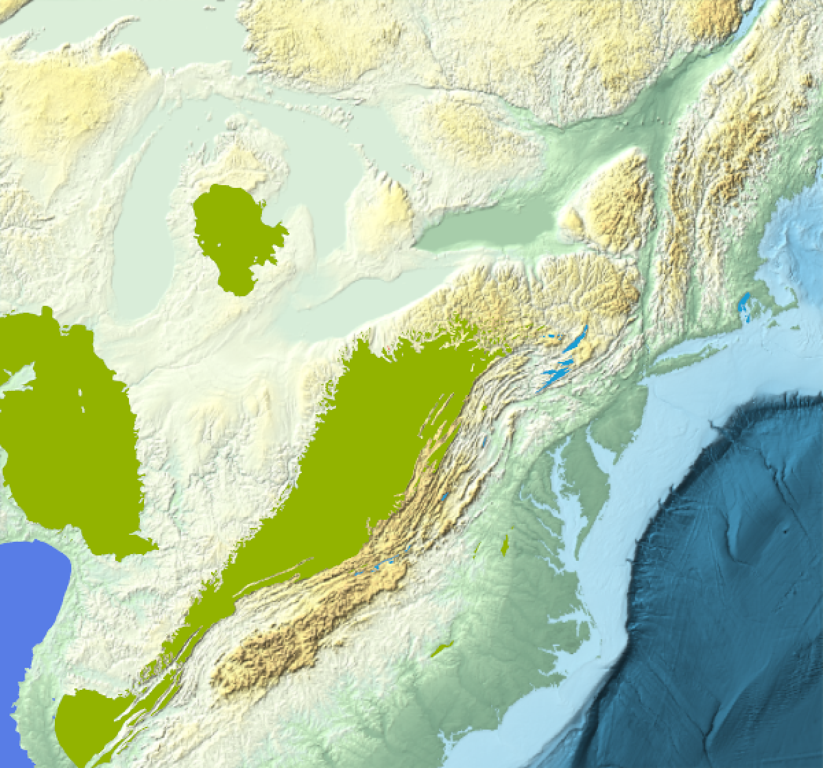
Coal from the Rocky Mountains is found in more isolated pockets of varying ranks, typically lower ranked compared to the deposits found further east.