In[]:=
tokyoCoords=GeoPosition[CityData[{"Tokyo","Tokyo","Japan"}]];ent=EntityValue;fullCoords=Flatten[ent["FullCoordinates"],1];(*iwasn'tsurewhythepointswheregroupedthewaytheywere.IthinkIjustwantarawlistofGeoPosition[]pointssothat'swhyIflattenittolevel1*)USEdges=GeoPosition[{#1,#2}]&@@@fullCoords;GeoGraphics[USEdges]
Out[]=
In[]:=
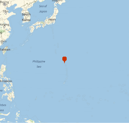
dists=GeoDistance[USEdges,tokyoCoords]//Normal;minPt=USEdges[[First@Ordering@dists]]GeoGraphics[GeoMarker[minPt],GeoRangeQuantity[1500,"Miles"]]
Out[]=
GeoPosition[{20.5515,144.889}]
Out[]=