Determining Latitude from Maximum Solar Altitude
Determining Latitude from Maximum Solar Altitude


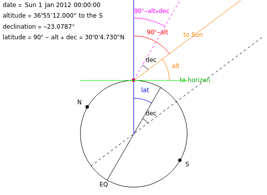
Navigators have traditionally used sextants to determine the latitude of their ships. Sextants work by measuring the altitude of a celestial body (the angle between the observer’s local horizon and the celestial body). By measuring the altitude of the Sun when it reaches its maximum (local noon), it is possible to compute the latitude of the observer. This Demonstration allows the calculation of latitude, based on a given altitude measurement of the Sun and the time of year.
Details
Details
Determining latitude () from the altitude () of the Sun at local noon requires knowledge of the declination () of the Sun as seen from Earth. The declination of the Sun is the angle between the rays of the Sun and the plane of the Earth’s equator (EQ) and varies between 23.44°N at the northern summer solstice and 23.44°S at the northern winter solstice. If the altitude of the Sun is observed due south, the observer’s latitude may be calculated by . If the altitude of the Sun is observed due north, the observer’s latitude may be calculated by .
lat
alt
dec
lat=90°-alt+dec
lat=90°-(180°-alt)+dec
Permanent Citation
Permanent Citation
Joshua Goldstein
"Determining Latitude from Maximum Solar Altitude"
http://demonstrations.wolfram.com/DeterminingLatitudeFromMaximumSolarAltitude/
Wolfram Demonstrations Project
Published: April 12, 2012